FracCrews#
A frac crew is the team required to run a successful hydraulic fracturing operation.
This function returns the location of the frac crews by date. This is useful for keeping track of the number of crews for a given location, date and/or operator.
Syntax#
- =SMX.FracCrews(Aggregate By, Operator, Region, Subregion, County)
Arguments#
Parameter |
Description |
Example |
|---|---|---|
Aggregate By |
Specifies a parameter by which to aggregate data. |
|
Operator |
Limit search by the name of the operator whose wells to retrieve. |
|
Region |
Limit search by the name of the region where the wells are located. |
|
Subregion |
Limit search by the name of the subregion where the wells are located. |
|
County |
Limit search by county where the well is located. |
|
Data can be aggregated by: county, date, operator, region, service_company, state_code, sub_region.
Note
Performance considerations: This function may take some time to retrieve and organize large amounts of data. For best performance, it is recommended to limit the number of input parameters and retrieve only the data needed for analysis.
Note
No Data: Output data will return “#No Data” when input data is invalid or does not exist.

Examples#
To retrieve frac crew data by a specific region:
=SMX.FracCrews(,,"GULF")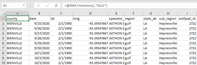
To retrieve frac crew data for a specific operator and subregion:
=SMX.Fraccrews(,"EXXON MOBIL",,"West - TX")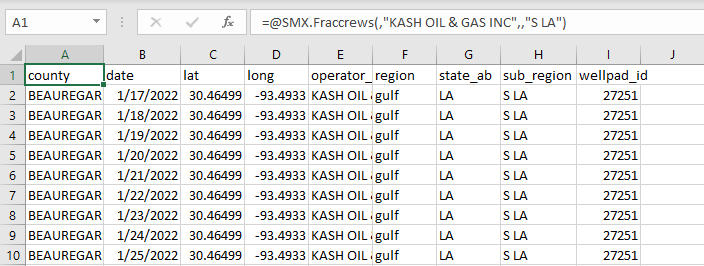
To retrieve frac crew data with a operator and county:
=SMX.Fraccrews(,"AETHON ENERGY OPERATING LLC",,,"SAN AUGUSTINE")
To retrieve frac crews aggregated by operator:
=SMX.FracCrews("operator")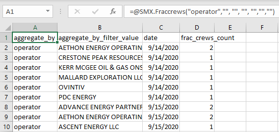
Output Parameters#
Field |
Type |
Description |
Example |
|---|---|---|---|
county |
string |
County in the state where the well is located. |
“BEAUREGARD” |
date |
string |
Frac crew location date. Date formatting - [“YYYY-MM-DD”] |
“2022-06-01” |
frac_class |
string |
Classifies wells as either oil or gas wells based on the GOR definition from the EIA. |
“oil” |
lat |
string |
The latitude of the location, in decimal degrees; follows the WGS 84/EPSG:4326 coordinate system. |
“32.2483475” |
long |
string |
The longitude of the location, in decimal degrees; follows the WGS 84/EPSG:4326 coordinate system. |
“-93.39548666666667” |
operator_name |
string |
Operator of the well. |
“PIE OPERATING, LLC” |
region |
string |
Aggregation of multiple major producing basins. |
“GULF” |
state_ab |
string |
Abbreviation of the state. |
“LA” |
sub_region |
string |
Aggregation of several counties, typically representing a major producing basin. |
“S LA” |
wellpad_id |
string |
Identifier of the wellpad. |
27248 |
service_company |
string |
Name of the service company associated with the DUCs. |
“Liberty” |
frac_crews_count |
integer |
Number of frac crews available for well completions. |
1 |
Note
Wellpads located in Canada are tracked and identified by a prefix ‘C’ in the wellpad id.
Errors#
Functions may return the following error messages:
Error |
Description |
|---|---|
#VALUE! |
Input parameters are invalid or cannot be parsed. |
#REF! |
The function cannot retrieve data from the SynMaxax API due to a network or connectivity issue. |
!!! EXCEPTION |
Invalid input parameters. Make sure dates are enclosed in quotes. Check if the API key is valid. To know more about how to use an API key, please check the section on authentication. |
#No Data |
Input data is invalid or does not exist. |
Note
You can also check the logs for more information on errors. You can access the logs by clicking on SynMax Energy on the Excel ribbon and then clicking on Logs.